 || An Introduction to Meteorology
Climate & Weather: What's the Difference?
Climate: Is what you Expect...
Weather: Is what you Get...
Climate: Is about Long-Term Records, Trends and Averages...
Weather: Is the Day to Day Experience...
Climate: Is the Sum or Synthesis of all the Weather recorded over a Long Period of Time. It tells us the Average or most Common Conditions, or Extremes, or Counts of Events, or Frequencies...
Weather: Is a Description of Conditions over a Short Period of Time - a "Snap Shot" of the Atmosphere at a Particular Time...
The Atmosphere
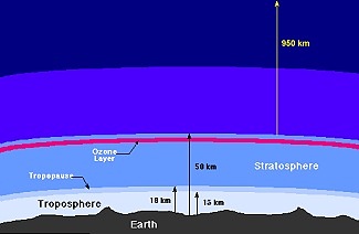
The Atmosphere consists of an Ocean of Air, extending out to 1,000 km from Earth's Surface (or about one-seventh Earth's Radius).
All Weather processes take place in the Lowest 10-15 km of the Atmosphere. This is called the Troposphere and its upper boundary with the Stratosphere is called the Tropopause.
Pressure falls with Height, from about 1,000 hPa (hectopascals) at the Earth's Surface to about 200 hPa at the Tropopause.
Temperature also generally falls with Height throughout the Troposphere, at an average rate of about 6°C/km.
Weather
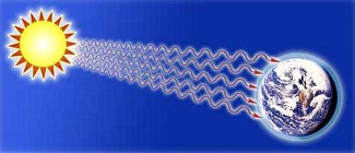
The Weather Systems are Devices that spread the Solar Energy from the Equator towards the Poles. Note that the Earth's Mean Temperature does not change significantly, so there must be a Balance between the Energy absorbed from the Sun and the Energy Re-Radiated to Space.
This Solar Energy is then Distributed around the World in a Variety of Ways.
The Sun's Radiation is the Source of Energy that drives the Weather System in the Troposphere.
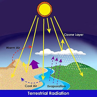
Heat and Moisture are the two Prime Causes of all Weather Conditions. Except for Localised Factors such as Bushfires, Volcanoes or Nuclear Explosions, the Heat Source for the Earth's Weather is the Sun.
Most Solar Radiation is received in the Equator Regions. This comes through the Atmosphere and Heats the Earth and Sea below. The Atmosphere is then Warmed from below by the Warm Land and Sea. This Warming Causes the Air to Rise in these Regions and flow towards an Area of Lower Pressure. This Process was first described by Hadley in the 18th Century to Explain the Trade Winds.
Basically Hot Air rises near the Equator (Low Pressure) and is replaced by Cooler (High Pressure) Air from the Poles.
Detail of a Hadley cell

The Landmasses, which heat up quickly and Cool Equally quickly, produce Heat Radiation into Specific Areas.
The Sea, which retains its Heat for much Longer Periods, results in the Heating of Air from Cooler Regions or the Cooling of Warmer air from Landmasses.
As the Land changes Temperature throughout the Day a pattern of Land and Sea breezes is created along the Coast.
In fact, there are three of them: the Hadley Cell at the Equator, the Farrell Cell in Mid-Latitudes, and the Polar Cell.
The Polar Cell sinks here. The Atmosphere sinks here in Large Part because the Pole is covered with Ice and is very Cold. This Circulation, along with the Farrell Cell, determines the path of Jet Streams. Jet Streams tend to move down the Interface between the Polar Cell and the Farrell Cell. And of course the Jet Stream Paths determine storm tracks and Precipitation Patterns.

The pattern occurs as follows:
-
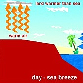
As the Sun Heats the Land, Air in contact with the Land is Heated and Rises.
-
Air over the adjacent Water remains a comparatively Cooler Temperature and flows onto the Land to replace the Air that has risen.
-
The Wind that flows in from the Sea is called the Sea Breeze, it is Temperature driven and will attain Maximum Strength about Mid-Afternoon.
-
As the Heat goes out of the Day the Sea Breeze will become gentle towards Evening. If there is very little Pressure Gradient the Sea Breeze will generally Average 15-18 knots (28 - 33 km/h) and will not extend more than 20 miles (32 km) from the Coast.
-
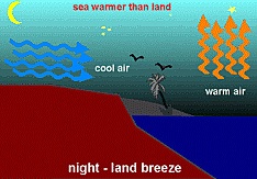
At Night the opposite Effect occurs.
-
As the Land Cools Down the Cool Air flows Downhill off the Land and out to Sea to displace the comparatively Warmer Air over the Water.
-
This Land Breeze (Flowing off the Land) is usually Fairly Gentle (4-6 knots or 7 - 11 km/h) and does not extend far out to Sea (5-10 miles - 8 - 16 km).
The Moisture source is, the Sea and the combination of the Sun's Heat and the Resultant Evaporation of the Sea Surface produces the Moisture content in the Air. When Air is Warmed it becomes Lighter and Rises. This Lighter Air registers as a 'LOW' Pressure on a Barometer.
The Barometer
-
The Barometer measures Atmospheric Pressure or the 'Weight' of the Air.
-
Cold Upper Atmosphere Air sinks because it is Heavy and Registers as 'High Pressure' on the Barometer.
-
Large Areas of High and Low Pressure are represented on a Weather Chart as successive High and Low-Pressure Systems.
-
Air will always flow from High to Low Pressure and it is this Air Movement that we know as Wind.
The Difference in Pressure over a Distance is the 'Pressure Gradient' and directly affects Wind Strength.
If the Difference in Pressure over a Particular Distance Increases, the Pressure Gradient is said to become Steeper and the Wind will Strengthen. Pressure Gradient is represented on a Weather Chart as the Distance between the Isobars.
The Clouds are the result from the Upper Movement of Moist Air that Condenses when reaching the Cooler Upper Atmosphere. This Air is Condensed into Droplets of Water, which form around Dust or Salt Particles to form Visible Clouds.
The effect of clouds on the weather is twofold:
1. The Degree of Cloud Cover will restrict both the Heating Effects of the Sun and the Earth's ability to Radiate Heat Outwards. This can be the cause of keeping an Area Cool or Warm.
2. The Effect of the Latent Heat released into the Atmosphere during the Condensation Process and the Subsequent Precipitation in the form of Rain.
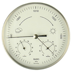
Barometer to measure Air Pressure Systems



 Each Hemisphere has 3 giant Atmospheric Cells (shown 1) which Define the Prevailing Surface Winds around the entire Earth

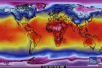 World Surface Temperatures on Oct 17, 2012
 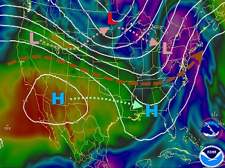 Forecast Jet Stream Pattern across North America , October 2012.